In 1375, a mapmaker working on the Mediterranean island of Majorca assembled a world that no single traveler had ever seen. The result did not merely trace coastlines. It placed wind lines across the sea, kings on distant thrones, caravans beside deserts, Christian sacred history near reports from merchants, and fabulous peoples at the margins of imperfect knowledge. Known today as the Catalan Atlas, this extraordinary manuscript is at once a navigational instrument, a political portrait, an encyclopedia, and a work of art.
Its contradictions are precisely what make it valuable. The Mediterranean is rendered with the practical confidence of generations of sailors, while parts of Asia and Africa mingle observation, hearsay, classical inheritance, and religious tradition. To modern eyes that mixture can look inconsistent. To a fourteenth-century patron, however, it offered something more ambitious than a chart: an organized vision of a connected world. Reading the atlas well therefore requires more than identifying what its makers got “right” or “wrong.” It requires asking how information moved, who controlled it, and what a map was expected to do.
A Manuscript Made to Be Unfolded and Read
The Catalan Atlas is usually dated to about 1375 and is preserved in the Bibliothèque nationale de France in Paris as manuscript Espagnol 30. Rather than a single sheet, it consists of twelve parchment half-sheets, now mounted as six double panels. Each half-sheet measures roughly 64 by 25 centimeters. When placed together, they form an extended object that invites a reader to move across it section by section rather than take in the whole world at one glance.
The first panels are devoted largely to cosmography, the calendar, astronomy, astrology, and explanations of time. The remaining panels form a world map stretching from the Atlantic and Mediterranean eastward across Asia. This arrangement matters. The atlas does not treat geography as a detached inventory of places. Earth is situated within a larger ordered cosmos, and human travel is related to seasons, celestial cycles, and religious chronology. Its users could consult the object as a compendium of knowledge as well as examine its ports and routes.
The surviving work is lavishly illuminated with gold and strong colors. Cities appear as miniature architectural signs; rulers sit enthroned; ships and caravans animate spaces that would be empty on a modern political map. Text fills interiors and seas with information. This density signals that the artifact was not an ordinary working chart exposed to saltwater and hard use aboard ship. Its detailed painting and expensive materials point toward an elite audience. Yet it drew on practical nautical knowledge. Calling it either “art” or “navigation” misses the deliberate combination.
Abraham Cresques and the Problem of Attribution
The atlas is traditionally and strongly attributed to Abraham Cresques, a Jewish mapmaker and maker of navigational instruments active in Palma, Majorca. Documentary evidence identifies him as a skilled specialist in maps and compasses. The political authorities of the Crown of Aragon valued such expertise, and later records connect the Cresques family to prestigious cartographic commissions. Abraham’s son, Jehuda—later known after conversion as Jaume Riba—also worked as a cartographer and may have participated in the family workshop.
It is tempting to turn those facts into a neat signature story: one named genius creates one masterpiece for one royal client. The manuscript itself does not permit that certainty. It is unsigned. Scholars infer its origin from its date, language, style, and relationship to documented Majorcan production. Some accounts give Abraham sole authorship, while others allow a role for Jehuda or workshop assistants. “Attributed to Abraham Cresques” is therefore more accurate than presenting authorship as an uncontested fact.
Why Fourteenth-Century Majorca Became a Cartographic Crossroads
Majorca’s location helps explain the atlas. The island sat amid the commercial arteries of the western Mediterranean and belonged to the Crown of Aragon’s maritime world. Ships connected it to Iberian ports, North Africa, Italy, and the wider Mediterranean. Merchants, pilots, diplomats, pilgrims, and captives carried news alongside cargo. Geographic knowledge accumulated through repeated movement, and practical information about harbors and sailing directions could meet stories arriving from much farther away.
Majorca was also religiously and linguistically plural, though never peacefully equal. Christian rule encompassed Jewish and Muslim communities whose knowledge, occupations, and contacts crossed cultural boundaries. Jewish scholars and craftsmen could work in Arabic, Hebrew, Catalan, and Latin intellectual environments. Abraham Cresques’s career demonstrates both opportunity and vulnerability: his expertise was desired by rulers, but Jewish life remained constrained by Christian power and would face escalating violence in the following decades.
Portolan Precision Around the Mediterranean
The map’s most immediately technical feature is its relationship to the portolan chart tradition. Portolan charts, which appeared in the Mediterranean by the late thirteenth century, emphasized coastlines, harbors, islands, and networks of directional lines. They were especially strong where generations of mariners had accumulated experience. On the Catalan Atlas, the Mediterranean and Black Sea coasts are far more recognizable than many inland regions. Coastal place-names crowd the shores, often written perpendicular to the coastline so they remain readable without occupying the sea.
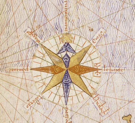
A web of rhumb or wind lines crosses the maritime space. These lines do not form a modern grid of latitude and longitude. Instead, they express directional bearings associated with compass navigation. Their presence, along with carefully differentiated ports and islands, linked the atlas to practical seafaring knowledge. An elaborate compass rose is another famous feature. It is sometimes advertised as the first compass rose ever drawn, but absolute “firsts” are hazardous when survival is accidental. It is safer to call it one of the earliest celebrated examples.
A Hybrid World Map, Not a Failed Modern One
Scholars often describe the Catalan Atlas as a hybrid of the portolan chart and the medieval mappamundi. The phrase captures how it combines two mapping habits. From nautical charts came detailed coasts and directional networks. From encyclopedic world maps came sacred history, rulers, marvels, moral geography, and written explanations. The resulting object did not separate measurable space from meaningful space as sharply as many modern maps do.
That does not mean its makers were confused about the difference between a harbor and a legend. Different visual claims served different purposes. A coast used by sailors could be repeated from navigational models. A distant ruler might be represented as a crowned type rather than a portrait. A note about a fabulous people could preserve an authoritative textual tradition without implying eyewitness verification. The atlas arranged knowledge by degrees of access, although it did not mark those degrees with a modern citation system.
Calling the map “inaccurate” without identifying its purpose imposes the wrong test. No reader could use its entire world surface as a uniformly scaled route planner. That was not the only standard of value. It displayed reach: the patron could see trade, faith, political power, and travel stories joined within one ordered artifact. Where reliable navigational knowledge existed, the atlas used it. Where information was indirect, it made uncertainty visible through dense textual and pictorial traditions, even when modern viewers mistake that density for simple credulity.
Mansa Musa and the Geography of Gold
Among the atlas’s best-known images is a Black ruler seated in West Africa, holding a gold object. The accompanying legend identifies him as Musa, ruler of Mali, and associates his lands with abundant gold. The figure is commonly recognized as Mansa Musa, whose pilgrimage to Mecca in 1324–1325 made a powerful impression in Egypt and the Mediterranean. Reports of his wealth traveled widely, and Mali became imaginable to European mapmakers through its place in trans-Saharan exchange.
The picture is historically revealing, but it is not an eyewitness portrait. The artist used the visual language of kingship: crown, throne, rich clothing, and conspicuous gold. The image communicates status and economic importance more than individual appearance. Nor should the golden object be treated as a precise measurement of Musa’s fortune. Medieval chroniclers and later storytellers often magnified spectacular wealth. What can be confirmed is that Mali controlled access to major gold-producing regions and that Musa’s pilgrimage broadcast the empire’s power far beyond West Africa.
The depiction also challenges the notion that medieval European maps ignored sub-Saharan Africa. The knowledge was incomplete and filtered through North African commerce, diplomacy, and textual reports, but it was not absent. The atlas places West African wealth within a connected Mediterranean economy. For a fuller account of the ruler behind the image, see our history of Mansa Musa and the Mali Empire. The map’s importance lies less in proving one sensational fortune than in showing how African political and economic realities entered European geographic imagination.
Asia Through Merchants, Missionaries, and Mongol Power
East of the Mediterranean, the atlas expands into a landscape of caravan routes, cities, mountains, rulers, and written reports. Its makers had no direct survey of Asia. They assembled information circulating in the wake of the Mongol empires, which had made long-distance passage across Eurasia more feasible for certain travelers during the thirteenth and fourteenth centuries. Accounts associated with Marco Polo, the Franciscan traveler Odoric of Pordenone, and other itineraries helped furnish western readers with names, distances, commodities, and courtly descriptions.
The Great Khan appears enthroned, and routes evoke the movement of merchants across Inner Asia. These elements record a genuine widening of information. Europeans knew more about parts of Asia in 1375 than many of their predecessors had known two centuries earlier. Yet “knew more” is not the same as possessed a comprehensive, current map. Reports were copied, translated, compressed, and combined. Political conditions could change before an account reached a workshop. Familiar names might be attached to uncertain positions.
The atlas therefore preserves both the achievement and the limits of networked knowledge. It shows information traveling without requiring the mapmaker to travel personally. That process resembles a medieval form of compilation: authority came from comparing inherited texts with news supplied by merchants and envoys. Modern readers should resist the romance of a secret expedition by Abraham Cresques. There is no evidence that he crossed Asia. His skill lay in evaluating and arranging many streams of testimony into a persuasive visual whole.
Jerusalem, Sacred History, and the Christian Courtly Audience
Religious geography remains central even in this commercially alert map. Jerusalem occupies a privileged symbolic position, and biblical or Christian references appear across the world. Medieval Christian readers understood terrestrial history as part of sacred time, from Creation through biblical events toward the Last Judgment. A world map could therefore teach chronology and salvation history while also naming real ports and kingdoms.
Here the atlas’s Jewish attribution and Christian destination demand careful interpretation. Abraham Cresques could work for Christian rulers and employ visual and textual conventions suited to their expectations without erasing his own community’s intellectual background. A commissioned object was shaped by patronage. The map’s Christian content does not disprove Jewish authorship; nor does Jewish authorship make the atlas a simple celebration of religious tolerance. It reflects professional accommodation within unequal political relations.
The likely presence of the manuscript in the library of the French king Charles V by the late fourteenth century reinforces its courtly setting. Historians have debated the precise circumstances of its commission and movement from Majorca to France. Popular summaries sometimes state confidently that it was created specifically as a gift for Charles V. The royal connection is strong, but the exact path is less certain than that formula suggests. What matters is that the atlas suited a royal collection: it converted geographic information into an image of learned, expansive sovereignty.
Legends, Marvels, and the Edges of Verification
The Catalan Atlas includes material that no historian would accept as observed geography: traditions of Gog and Magog, stories connected to Alexander the Great, fabulous races, and marvels inherited from classical and medieval literature. Their presence has often been used to contrast a supposedly superstitious Middle Ages with a rational modern age. That easy opposition fails to explain why the same object can render Mediterranean coasts with remarkable care.
Compilers worked within hierarchies of authority different from ours. A claim found in an esteemed ancient author, scripture, or a respected travel narrative could deserve preservation even when direct verification was impossible. Marvels also served intellectual and moral purposes. They marked distance, otherness, danger, and the limits of ordinary experience. On a luxury atlas, they made remote regions memorable and visually compelling.
This does not require assuming that every viewer believed every story literally. Medieval readers could compare authorities, recognize allegory, and express doubt. The map offers no opinion poll of its audience. Its legends are evidence that certain traditions remained culturally available, not proof of universal credulity. A responsible reading separates confirmed features—such as the map’s physical construction and its use of known travel accounts—from unverified claims represented within it. The distinction lets us study medieval belief without repeating the legends as facts or mocking the people who preserved them.
What the Atlas Reveals About Information Networks
No archive contains the complete chain by which every name and image reached Majorca. Even so, the atlas allows historians to reconstruct categories of transmission. Sailors contributed repeated coastal experience. Merchants carried news of markets, rulers, and overland routes. Diplomats and pilgrims returned with political and religious observations. Written works preserved information from travelers who had journeyed decades earlier. Map workshops copied earlier charts while revising selected details. Translation connected Arabic, Catalan, Latin, Hebrew, and other linguistic worlds.
Information did not move neutrally. A ruler’s wealth was emphasized because it mattered to trade or diplomacy. A city sacred to Christians received symbolic prominence. An unfamiliar population might be reduced to a marvelous stereotype. Names could be distorted in translation. The atlas is thus a record not simply of what Europeans “knew,” but of which reports became portable, credible, useful, or visually attractive within elite networks.
How the Manuscript Reached France—and What Remains Uncertain
The atlas is documented in the French royal collection associated with Charles V, a monarch known for cultivating a substantial library. Its arrival there links Majorcan expertise to the political culture of the Valois court. Royal libraries were not passive storehouses. Manuscripts displayed learning, supported counsel, and expressed the ruler’s command of history and space. A richly painted world map was particularly suited to those purposes.
Beyond that broad outline, certainty narrows. The common date of 1375 is accepted as approximate, while the patronage arrangement and delivery story are reconstructed from later inventories and related documents. A separate Aragonese royal order from 1381 requesting a world map from the Cresques family is important evidence for their reputation, but it should not automatically be treated as the commission for this surviving manuscript. Similar descriptions can refer to different objects.
Historians therefore distinguish provenance from legend. The atlas’s material style, language, and cartographic context support a Majorcan origin and Cresques attribution. Its presence in France is documented. The exact negotiations joining those facts remain debatable. This gap is not a failure of scholarship; it is a normal consequence of fragmentary medieval records. Good history keeps the secure points in view while refusing to fill the interval with an invented scene of presentation at court.
Why the Catalan Atlas Still Matters
The Catalan Atlas matters because it makes the medieval world simultaneously larger and more connected than familiar stereotypes allow. Fourteenth-century Europeans did not possess complete global knowledge, but neither were they confined to a tiny intellectual horizon. Their maps could incorporate West African empires, Mongol courts, Indian Ocean commerce, Mediterranean navigation, biblical history, and inherited legends within one visual system.
It also demonstrates that accuracy is local and purpose-dependent. The coastlines around the Mediterranean benefited from dense practical experience; distant interiors relied more heavily on textual compilation. Courtly spectacle shaped the whole. Instead of ranking the object on a single ladder from error to truth, historians can ask what evidence supported each region, which conventions signaled authority, and who benefited from the completed image.
Finally, the atlas reminds us that maps do not simply reflect worlds; they help create them. By selecting rulers, routes, resources, sacred centers, and marvels, the map gave its viewers a structured account of power and difference. Its makers joined information from people who would never meet. Its royal owners received that collective knowledge as a beautiful possession. The result is not a transparent window onto 1375, but something more revealing: a record of how a sophisticated medieval workshop transformed uncertain, unequal, far-reaching connections into a world that could be read.
Sources and Further Reading
- Bibliothèque nationale de France, Mandragore catalogue record for Espagnol 30.
- Bibliothèque nationale de France, “Mediterranean and Atlantic” panel from the Catalan Atlas.
- Cambridge University Press, “Journeying to the World’s End” in Mapping Medieval Geographies.
- Cambridge University Press, “Geography” in The Cambridge History of Science.
- University of Chicago Press, The History of Cartography, Volume 1, chapter 1.