Around 1050, communities near the Mississippi River began remaking their world on a startling scale. People leveled plazas, shifted neighborhoods, raised timber buildings, and carried millions of baskets of earth to create monumental mounds. Within decades, a settlement near present-day St. Louis had become the largest known pre-Columbian city north of Mexico.
That city is now called Cahokia, although no surviving evidence tells us what its inhabitants called it. At its height, it may have held 10,000 to 20,000 people in its central area, with many more living across the surrounding American Bottom. The numbers remain estimates, but the urban achievement does not. Cahokia was a political, ceremonial, and economic center whose influence reached far beyond its plazas.
Its history is also easy to distort. Cahokia was not an isolated mystery built by an unknown “lost race,” and its decline cannot be reduced to one drought, flood, or act of environmental destruction. Archaeology instead reveals an Indigenous city created by migration, planned labor, farming, ceremony, and contested authority. Its story belongs at the center of North American history.
The urban transformation began around 1050
People had lived in the Mississippi Valley for thousands of years before Cahokia’s expansion. Villages in the American Bottom cultivated crops, hunted, fished, and traded long before the eleventh century. What changed around 1050 was not the arrival of civilization in an empty landscape, but the speed and scale at which existing communities were reorganized.
Archaeologists sometimes call this rapid shift the “Big Bang” of Cahokia. Older settlements were altered or abandoned while a much larger concentration appeared near Cahokia Creek. Houses were constructed in planned arrangements, public spaces were cleared, and mounds rose in successive building stages. New settlements also developed east of the central precinct and in farming districts that supplied the growing population.
The chronology comes from radiocarbon dates, pottery sequences, building remains, and the layering of mound construction. These sources do not identify a founder or record a proclamation announcing a new capital. They show collective action. Large numbers of people accepted, negotiated, or were compelled to participate in a new social order.
Why the transformation occurred remains debated. Scholars have proposed charismatic religious movements, political consolidation, population growth, agricultural opportunity, and the attraction of public ceremonies. These explanations are not mutually exclusive. A favorable climate and productive floodplain could support growth, while leaders and ritual specialists gave that growth a political form. The evidence supports a major reorganization; it does not reveal a single moment when one ruler “founded” Cahokia.
A river landscape supported the city
Cahokia stood in the American Bottom, a broad Mississippi River floodplain with rich soils, wetlands, lakes, forests, and access to waterways. This environment offered an unusually varied food base. Residents grew maize and other crops, collected nuts and plants, hunted deer and smaller animals, and caught fish. The river connected communities rather than separating them.
Maize agriculture was crucial, but the city was not sustained by corn alone. Earlier Eastern Agricultural Complex crops, including native seed plants, remained important, and households used different combinations of cultivated and wild resources. Food production depended on practical knowledge of seasonal flooding, soils, storage, and labor. It also depended on surrounding settlements. Cahokia should be understood as the center of a populated region, not a dense island surrounded by wilderness.
The city’s setting created risks as well as advantages. Floods could damage low-lying areas; drought could reduce harvests; and a large population required fuel, timber, food, and clean water. Older interpretations sometimes blamed Cahokians for simply exhausting their environment. Research summarized by the Illinois State Archaeological Survey is more cautious: sediment studies do not support a simple story of reckless local ecological destruction.
Climate still mattered. Wet conditions in the eleventh century may have supported the initial expansion, while later droughts placed pressure on farming and regional settlement. Environmental change influenced political choices and household decisions, but it did not act like a switch that automatically turned urban life on or off.
Monks Mound anchored a planned landscape
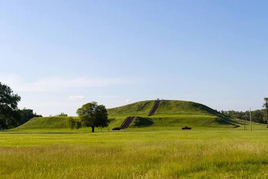
The most imposing surviving structure is Monks Mound, named after Trappist monks who lived nearby centuries after Cahokia’s decline. The Indigenous builders created it in stages from carefully selected soils. Its base covers more than five hectares, and its surviving height is about 30 meters. It remains the largest prehistoric earthen construction in the Americas by volume north of Mexico.
Monks Mound was not a natural hill. Basket loads of soil were placed, shaped, and repaired across generations. Different soil colors and textures helped builders manage drainage and stability, although parts of the monument later slumped. Structures once stood on its terraces and summit. The largest summit building may have been associated with leadership, ritual, or both, but its precise functions cannot be recovered from architecture alone.
South of the mound lay the Grand Plaza, an enormous leveled space. Excavation has shown that its flat surface was deliberately created rather than conveniently inherited from nature. The plaza could accommodate ceremonies, games, gatherings, and political performances. Surrounding mounds and buildings turned movement through the center into an experience shaped by authority.
The site originally contained perhaps 120 mounds of different forms and uses. Some supported buildings; some marked burials; others defined public space. About 80 survive in varying condition. Modern roads, farming, and urban development destroyed or damaged many features before preservation efforts expanded. The UNESCO World Heritage property protects the core, not the full extent of Greater Cahokia.
Cahokia’s population was large and diverse
Estimates for central Cahokia at its peak commonly range from 10,000 to 20,000 people. The broader region may have held tens of thousands more. Exact figures vary because archaeologists estimate population from house remains, occupation phases, settlement area, and assumptions about household size. A maximum estimate should not be presented as a census.
Even the lower estimates make Cahokia exceptional in eleventh- and twelfth-century North America. Yet size is only part of its importance. Isotopic studies of human teeth indicate that many residents were not born locally. The city drew migrants from other parts of the Midwest and perhaps farther away. Pottery styles and domestic practices likewise point to people with different backgrounds living in and around the urban center.
This diversity challenges the picture of Cahokia as a single tribe expanding from one village. It may have been a place where newcomers entered new neighborhoods, alliances, and ritual communities. Migration could strengthen the city by adding labor and connections, while also creating tensions over identity, land, and status.
Archaeologists cannot assign every household to a named modern nation. Several Native peoples have historical and cultural relationships with the wider Mississippian world, but direct lines of affiliation must be handled with care and in consultation with descendant communities. What can be stated firmly is that Cahokia was an Indigenous achievement. The old claim that Native North Americans could not have built it arose from colonial prejudice, not evidence.
Power, ceremony, and Mound 72
Cahokia’s monuments imply organized leadership, but archaeologists debate how power worked. Terms such as “chiefdom,” “state,” and “theater state” highlight different features: hereditary rank, centralized command, ritual performance, or networks of households and communities. No written constitution survives, and the city probably changed politically during its three centuries of prominence.
Burials in Mound 72 provide dramatic evidence of hierarchy and violence. Excavations uncovered hundreds of individuals in a complicated sequence of graves, including mass burials and people apparently killed as part of mortuary ceremonies. One celebrated burial was once described as a man placed on a platform of shell beads arranged as a bird. Later reanalysis found that the central burial included both a male and a female, correcting an interpretation shaped by assumptions about male rulers.
The mass graves are often summarized as proof of a single spectacular sacrifice. The actual excavation history is more complicated. Different burials were deposited at different times, and researchers disagree about the identities, origins, and meanings of those interred. Some victims may have been captives; others may have belonged to Cahokian communities. Ancient violence is confirmed, but a precise ritual script is not.
This distinction matters. Cahokia should be neither romanticized as entirely peaceful nor reduced to cruelty. Monumental labor, feasting, burial, and public ceremony could build solidarity while reinforcing inequality. Leaders may have ruled through generosity, sacred authority, coercion, or shifting combinations of all three. Mound 72 exposes the power of the city, but it does not explain every institution within it.
Trade connected Cahokia to a continental world
Materials recovered at Cahokia came from distant regions. Marine shell reached the Mississippi Valley from the Gulf Coast; copper circulated from the Great Lakes; stone and minerals moved through extensive exchange routes. Cahokian-style objects and ideas also appeared at sites across the Midwest and Southeast. These connections were social and political as well as economic.
Trade was not a modern market in which standardized currency bought imported luxuries. Goods could be exchanged as gifts, tribute, ritual objects, marriage payments, or signs of alliance. Skilled craftspeople worked shell, copper, stone, clay, and wood. Their products communicated status and religious ideas while binding Cahokia to other communities.
The city’s influence did not mean it governed the entire Mississippian world. “Mississippian” is an archaeological label for related societies that shared some practices, including maize agriculture, platform mounds, distinctive imagery, and regional exchange. These societies were diverse and politically independent. Cahokia was unusually large and influential, but it was not an empire stretching across the eastern United States.
Long-distance connections also carried stories and ceremonial forms whose meanings cannot be reconstructed fully from objects. Similar motifs do not prove identical beliefs everywhere. This is comparable to the care required when interpreting the monumental landscapes revealed by the Tikal LiDAR discoveries: archaeological patterns demonstrate complex networks, but they do not automatically identify a single political system.
Woodhenge tracked the sun—and organized gatherings
West of Monks Mound, archaeologists found circles of large postholes. Reconstructed examples are popularly called “Woodhenge,” a modern comparison with Stonehenge. The posts were rebuilt in changing circles over time, suggesting repeated planning rather than a one-time structure.
From a central observation point, particular posts aligned approximately with sunrise at solstices and equinoxes. This arrangement could help mark seasons important to farming and ceremony. It also created a place where people gathered to witness cosmological order expressed in the landscape. Calendar knowledge was not separate from political life: the ability to organize ceremonies at meaningful times could reinforce leadership.
Popular accounts sometimes turn Woodhenge into an astronomical observatory with modern scientific precision. The surviving evidence supports solar alignments, but not every proposed alignment is equally secure. Posts were replaced, circles differed in size, and interpretations depend on reconstructing which features belonged together.
The safest conclusion is also the most interesting. Cahokians built architecture that joined time, place, and community. Sunrise did not merely tell farmers when to plant. It could provide a public setting in which seasonal change, sacred meaning, and social authority became visible at once.
Why Cahokia declined remains disputed
Cahokia’s population began falling after its twelfth-century height. By about 1200, the center was much smaller, and by the mid-fourteenth century it had been largely abandoned. This was a long process, not a single night when the inhabitants disappeared. People moved elsewhere, joined other communities, and carried knowledge with them.
Drought is one leading explanation. Tree-ring and sediment evidence indicates episodes of reduced rainfall after the favorable conditions associated with Cahokia’s rise. A study by Larry Benson, Timothy Pauketat, and Edward Cook linked persistent droughts with the contraction of farming settlements and population loss. This correlation is significant, but drought alone does not explain why people responded by leaving rather than adapting in place.
Flooding has also been proposed, as have crop failures, disease, resource pressure, political conflict, and resistance to centralized authority. A palisade built around the central precinct required thousands of logs and may indicate insecurity, yet a wall does not reveal who threatened whom. It might reflect warfare, internal division, the protection of elites, or ceremonial boundary-making.
Recent research has weakened the once-popular claim that deforestation inevitably caused catastrophic flooding at the city. Other studies emphasize social instability, suggesting that Cahokia’s concentrated institutions became harder to maintain when climate, food systems, and political legitimacy came under pressure. These factors could reinforce one another.
There is no need to choose between a purely environmental and purely political collapse. Cities are relationships among people, resources, institutions, and beliefs. If migrants stopped arriving, harvests became less reliable, leaders lost authority, or households found better prospects elsewhere, urban concentration could unravel without a single final disaster. The disappearance of dense settlement was not the disappearance of its people.
The “lost city” label hides more than it reveals
European Americans did not discover an unknown city in the nineteenth century. Native communities knew the region, and mounds were visible landmarks. The name Cahokia came from a Native group living in the broader area during the colonial period, not from evidence that the medieval inhabitants used that name for themselves.
Early settlers and antiquarians often refused to believe that ancestors of Native Americans had constructed the mounds. They invented vanished races or attributed the earthworks to outsiders. Such theories helped portray Indigenous peoples as recent occupants who could be dispossessed. Archaeology has decisively rejected them.
Calling Cahokia “America’s forgotten city” may attract attention, but it can reproduce the same problem by implying that its history ended when the urban center declined. Mississippian societies continued across the Southeast and Midwest, and Native nations remain living communities rather than archaeological footnotes. Responsible interpretation connects the site to Indigenous continuity while avoiding unsupported claims that one modern nation alone can be equated with every Cahokian resident.
Cahokia changes the scale of medieval history. During the centuries when castles and cathedrals rose in Europe, Indigenous North Americans created a vast earthen city beside the Mississippi. Its plazas, neighborhoods, farms, and monuments were products of deliberate choices. Its decline was equally human: a series of adaptations, conflicts, and migrations rather than a civilization vanishing without explanation.
What Cahokia adds to world history
Cahokia demonstrates that urbanism has never had one blueprint. The city developed without stone palaces, wheeled transport, draft animals, or alphabetic writing. Those absences once caused outsiders to underestimate it. Archaeology shows instead that thousands of people could coordinate labor, move food and materials, maintain regional relationships, and create monumental public space through institutions adapted to their own world.
It also warns against treating population size as the sole measure of complexity. The city’s importance lay in the relationships concentrated there: migrants forming neighborhoods, farmers supporting gatherings, craftspeople transforming distant materials, and leaders making authority visible through mounds and ceremonies. These relationships changed over time, which is why no single label fully captures Cahokia’s political form.
The strongest history of Cahokia accepts uncertainty without turning it into mystery. We know when the urban surge occurred, how large its monuments became, and that its population later dispersed. We do not know the city’s original name, the exact powers of its leaders, or one final cause of decline. Those gaps are invitations to careful research, not permission to invent a lost race or a sudden apocalypse.
Research sources
UNESCO World Heritage Centre, “Cahokia Mounds State Historic Site”
Illinois State Archaeological Survey, “Cahokia”
Cahokia Mounds World Heritage and State Historic Site
Benson, Pauketat, and Cook, “Cahokia’s Boom and Bust in the Context of Climate Change”
Smithsonian National Museum of the American Indian, “Essential Understandings”