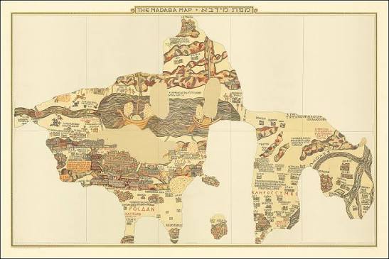
A visitor entering Saint George’s Church in Madaba, Jordan, can look down and see a city that disappeared more than fourteen centuries ago. Gates puncture an oval wall. Colonnaded streets cross between churches and public buildings. At the center stands Jerusalem, enlarged far beyond geographic scale and rendered as the spiritual capital of a Christian landscape. The image is not painted on parchment. It is assembled from thousands of colored stone tesserae set into a church floor.
Created in the sixth century, the Madaba Map is the oldest surviving geographic floor mosaic and the earliest extensive representation of the Holy Land preserved in its original medium. It names towns, rivers, tribal territories, shrines, and landscapes from the eastern Mediterranean to Egypt. Yet its greatest value lies in the tension between geography and belief. The mosaic contains remarkably specific urban information, but it is not a neutral survey. It shows how a Byzantine Christian community organized sacred history, contemporary architecture, pilgrimage, and local knowledge into one walkable vision of the world.
A Map Built Into the Floor
The surviving mosaic lies within the modern Greek Orthodox Church of Saint George in Madaba, southwest of Amman. It belonged to an earlier Byzantine building on the same site. Scholars usually date it to the middle or later sixth century, often around 560–565. That range is an inference from the structures it depicts, the history of the region, inscriptions, and artistic comparison rather than from a dated signature left by the mosaicists.
The original composition was substantially larger than the fragment visible today. Reconstructions commonly suggest a floor roughly twenty-one meters long and seven meters wide, though estimates vary because its borders and large sections have vanished. It probably extended from areas of present-day Lebanon or Syria in the north to the Nile Delta in the south, and from the Mediterranean coast eastward into the desert. More than a simple city plan, it was a regional panorama.
The work was made from small cubes of colored stone and glass. Roads, water, buildings, trees, animals, boats, and human figures once animated the landscape. Greek labels identified locations and sometimes quoted or paraphrased biblical texts. The mosaic was meant to be seen at architectural scale. A viewer did not hold it and rotate it like a paper map; the body moved beside or across an image embedded in a communal religious space.
Madaba in the Byzantine World
Madaba was not a remote village accidentally preserving an exotic artwork. In late antiquity it was a prosperous town in the Roman province of Arabia, situated east of the Dead Sea within a network of roads, agricultural settlements, bishoprics, monasteries, and pilgrimage routes. Its churches contained elaborate mosaics, and the surviving map belongs to a wider regional tradition of skilled floor decoration.
The sixth century was a period of energetic Christian building in the eastern Roman, or Byzantine, Empire. Under Justinian I, major churches were founded or renewed from Constantinople to Jerusalem. Pilgrims traveled to biblical sites, monasteries expanded, and local communities competed through architectural patronage. The Madaba mosaic reflects that world more directly than it illustrates the age of the apostles.
This context matters because the map is sometimes introduced as if it were a photograph of “biblical Palestine.” Its inscriptions draw on scripture and earlier geographic writing, but many visible cities are sixth-century Byzantine places. Jerusalem appears with churches that did not exist in biblical times. Readers interested in the politics of Justinian’s capital can compare this landscape with our account of the Nika Riots and the reign of Justinian. Both subjects show an empire in which monumental building, theology, and political authority reinforced one another.
Dating the Mosaic Through the Buildings It Shows
Jerusalem provides the most useful chronological clue. The mosaic includes a prominent basilica generally identified as the Nea Church, or New Church of the Theotokos, dedicated under Justinian in 543. The map must therefore postdate that event if the identification is correct. The great church was damaged or abandoned in later centuries, while the Persian conquest of Jerusalem in 614 changed the city’s Christian institutions and monuments.
Those boundaries support a sixth-century date, but they do not yield a single unquestionable year. Some scholars favor the 560s; others allow a broader mid-sixth-century range. Stylistic arguments and the sequence of regional church construction contribute to the discussion. The difference between “about 560” and “precisely 565” is important: the first states a scholarly consensus, while the second suggests documentary certainty that does not exist.
The map also contains features that may preserve older textual traditions alongside contemporary buildings. Its makers were not recording everything visible on one day. They combined current urban knowledge, biblical geography, inherited names, pilgrimage information, and artistic conventions. Dating the floor therefore requires distinguishing the age of the mosaic from the age of each source woven into it.
Jerusalem Enlarged Into the Center of Meaning
Jerusalem dominates the surviving composition. The city is drawn larger than surrounding places and enclosed by an oval wall with towers and gates. A broad colonnaded street runs through it, with another major street branching across the urban fabric. Churches and public structures are arranged to be recognizable even when strict scale and perspective are sacrificed.
The Church of the Holy Sepulchre receives particular emphasis. It appears in relation to the main street and other landmarks as the city’s sacred focus. The Nea Church also occupies a prominent position. This hierarchy reflects a Christian reading of Jerusalem shaped by pilgrimage and liturgy. Size measures importance as well as physical extent.
Even so, the image is not pure fantasy. Archaeology has confirmed key elements of the depicted street plan, including the principal cardo and major monuments associated with it. The mosaic helped researchers think about the position and appearance of Byzantine Jerusalem before later rebuilding altered the city. Its correspondence with excavated remains is impressive, but selective: the artists highlighted an intelligible ceremonial city rather than documenting every alley and house.
What the Greek Inscriptions Tell Us
The map originally contained a large body of Greek text, with well over one hundred labels surviving wholly or in fragments. Some simply name cities or regions. Others identify biblical events, tribal territories, churches, monasteries, or the tombs and shrines of saints. Text and image work together; a small architectural sign becomes a particular holy place because an inscription anchors it to memory.
Many identifications relate to the Onomasticon of Eusebius of Caesarea, a fourth-century catalog of biblical places later translated and revised by Jerome. The correspondence shows how written geography could guide visual geography. It does not prove that the mosaicists copied one manuscript mechanically. They also used local traditions and knowledge unavailable in Eusebius’s earlier compilation.
The inscriptions are evidence of audience as well as sources. Greek remained a major language of administration, liturgy, and learned culture in Byzantine Arabia. A literate cleric or pilgrim could connect the labels with scripture, while an illiterate viewer could recognize walls, rivers, roads, churches, and pictorial stories. The floor communicated on several levels at once.
A Landscape of Rivers, Fish, Boats, and Sacred Memory
Outside cities, the mosaic turns geography into narrative. The Jordan flows toward the Dead Sea. Fish appear in the river, while a famous detail shows them turning away from the intensely saline waters—a lively observation transformed into visual shorthand. Boats cross water, trees mark fertile places, and animals occupy the land. The map did not reduce territory to empty space between settlements.
Some human and animal figures were altered or damaged, possibly during periods when religious authorities objected to figural imagery. It is tempting to label every loss “iconoclasm,” but the causes are not equally certain. Wear, rebuilding, deliberate replacement, and later repair all affected the floor. The surviving map is the product of many interventions, not a pristine panel frozen since the sixth century.
Biblical time is layered onto the contemporary landscape. Places linked to patriarchs, tribes, prophets, and saints coexist with Byzantine roads and churches. This was not an error in chronology. Sacred history was understood as present in the land, and pilgrimage joined past events to current ritual. The map made that continuity visible beneath the feet of worshippers.
Was It a Pilgrim’s Guide?
The Madaba Map is often called a pilgrimage map, and the label captures part of its function. It identifies holy places and routes within a region visited by Christian travelers. A viewer could learn how Jerusalem, Bethlehem, Jericho, the Jordan, Mount Sinai, and other sacred locations related to one another. Monasteries and saints’ shrines receive attention that a fiscal or military map would not provide.
Yet it would have been an awkward portable guide. It was fixed to the floor and distorted scale according to religious importance. Roads do not form a complete turn-by-turn network, and surviving portions cannot show how all routes connected. Its value for pilgrims may have been educational and devotional rather than practical navigation during a journey.
Scholars also debate the exact function of the building that originally housed it. The traditional interpretation places it in a church, while newer arguments have reconsidered whether the room had secular, administrative, or mixed functions. The modern church does not reproduce the earlier structure perfectly. The safest conclusion is that the mosaic operated within a Christian civic environment where worship, patronage, education, and public display overlapped.
Accuracy Without Modern Scale
Modern viewers tend to ask whether an old map is accurate. The answer depends on what kind of accuracy is meant. The Madaba Map does not use a uniform projection, measured grid, or consistent scale. Jerusalem is exaggerated, and distances change according to available floor space and the importance of sites. North is not treated as the mandatory top in the modern manner.
At the same time, many relative positions, roads, urban features, and regional relationships are meaningful. The mosaicists knew central Transjordan and Judea better than remote edges of the design. Errors increase where information was less direct or where inherited texts competed with observation. That unevenness reveals how knowledge was gathered rather than proving that the whole work was merely symbolic.
The map’s strength lies in combining recognizable geography with a hierarchy of meaning. A modern transit diagram can distort physical distance while remaining useful because it clarifies connections. The comparison is imperfect, but it helps explain why lack of consistent scale does not equal lack of geographic thought. The Madaba artists selected and reorganized reality to answer the questions their community considered important.
Discovery During the Rebuilding of Saint George’s Church
The mosaic returned to wider scholarly attention in the nineteenth century, when Madaba was part of the Ottoman Empire. A Christian community resettling the town began building a new Greek Orthodox church over the remains of an earlier structure. In 1884, workers encountered the mosaic floor. The find was not immediately documented to modern archaeological standards.
Construction continued, and portions were damaged as foundations and columns were installed. Some tesserae were lost through exposure, repair, and ordinary movement. Recognition of the map’s full importance developed gradually. In the 1890s, clergy, scholars, and visitors produced descriptions and copies that brought it to international attention. Accounts sometimes name one “discoverer,” but the reality involved local builders, church authorities, and several early investigators.
This history complicates the romantic image of an archaeologist uncovering an untouched masterpiece. The mosaic survived because a religious community rebuilt on the site, yet the rebuilding also destroyed parts of it. Archaeological awareness, ecclesiastical needs, and heritage preservation did not align automatically. The fragment seen today records both Byzantine craftsmanship and nineteenth-century choices.
Conservation, Copies, and the Problem of Reconstruction
By the twentieth century, conservation was essential. The floor had suffered from structural disturbance, moisture, dirt, foot traffic, and earlier repairs. A major restoration campaign in the 1960s, associated especially with Heinz Cüppers and Herbert Donner, stabilized and documented the surviving mosaic. Their work also produced records and copies used by later researchers.
Restoration never simply reveals an original. Conservators must decide which tesserae are ancient, how to support loose areas, and whether missing sections should remain blank or be visually clarified. Early drawings can preserve details later lost, but they may include interpretation. Modern digital reconstructions can reunite fragments and labels, yet they should distinguish surviving evidence from conjectural completion.
The map’s fame has generated replicas in museums and public spaces. Copies make the composition easier to study than the irregular surviving floor, but they can create an illusion of completeness. A responsible caption should explain which outlines are ancient, which are reconstructed from early documentation, and which are modern guesses.
How Archaeologists Use the Madaba Map
The mosaic has guided research because it preserves names and visual relationships that disappeared from later landscapes. Scholars have compared its Jerusalem plan with excavated streets and churches. Other sites shown near the Dead Sea and across Jordan have been proposed as matches for ruins found on the ground. In some cases, the map strengthens an identification; in others, it remains one clue among several.
A location on the mosaic is not proof by itself. Names could shift, icons could be displaced for space, and artists could depend on texts rather than direct observation. Archaeologists test the map against inscriptions, pottery, architecture, roads, environmental evidence, and other written sources. When those lines converge, the map becomes powerful evidence. When they conflict, the disagreement may reveal change between periods or limitations in the mapmakers’ information.
Sensational reports sometimes claim that the mosaic “predicted” a discovery exactly. Such language exaggerates what historical cartography does. The map records sixth-century knowledge; modern archaeology evaluates that record. Its success is more interesting than prophecy because it demonstrates the sophistication of local geographic memory and artistic planning.
What the Map Leaves Out
Every map is an argument made through selection. The Madaba Map privileges Christian holy places, churches, and biblical associations. Jewish and Samaritan communities lived in the region, and imperial administration, agriculture, taxation, domestic neighborhoods, and military infrastructure shaped daily life, yet they do not receive equal visual emphasis.
The absence of a place or community does not prove it was unimportant or nonexistent. It shows that the patrons and makers had priorities. Jerusalem becomes a monumental Christian city because that is the Jerusalem the composition wanted viewers to understand. The mosaic is invaluable evidence for Byzantine perception, but it cannot stand alone as a complete social history of the Holy Land.
Its perspective is also local. The floor was produced east of the Jordan, within the landscape it depicts. Calling it simply a “European medieval map” erases the artisans and communities of Byzantine Arabia. Their work drew on imperial Christian culture while preserving regional knowledge and a distinctive mosaic tradition.
Why the Madaba Map Still Matters
The Madaba Map survives at the intersection of art, archaeology, theology, and cartography. It preserves a sixth-century image of Jerusalem detailed enough to converse with excavation, yet flexible enough to enlarge sacred centers and compress distance. It records written traditions while adding observations rooted in the region. Its tesserae are evidence not only of places but of the choices by which people made places meaningful.
It also teaches caution. The floor is incomplete; its date is approximate; its original room and full function remain debated; and early modern construction changed what survives. None of those limits reduces its importance. They make the object historically legible, because preservation and interpretation are themselves part of its story.
Most of all, the mosaic shows that a map need not imitate a satellite view to contain serious geographic intelligence. Its makers built a Christian landscape that could be read, remembered, and physically encountered. Fourteen centuries later, the surviving stones still connect streets uncovered by archaeologists with journeys imagined by pilgrims—and a vanished Byzantine city with the modern people standing above it.
Sources and Further Reading
- University of Oxford, Cult of Saints in Late Antiquity database: Madaba Mosaic Map.
- Smithsonian Institution, Guide to the Reproduction of the Madaba Mosaic Map.
- Byzantine and Modern Greek Studies, “Another reconsideration of the Madaba map”.
- Cambridge University Press, The Afterlife of the Roman City, chapter on porticated streets.
- Biblical Archaeology Society Library, “Understanding the Madaba Map”.